
AI-powered vegetation management: Advancing utility risk management
Vegetation management continues evolving as utilities navigate rising wildfire risks, regulatory scrutiny, and increased customer demands. Utilities are responsible for managing vegetation near power lines and other assets, given the far-reaching consequences of unmanaged growth. Vegetation-related risks, including power outages, fire hazards, and regulatory penalties, demand comprehensive strategies to protect infrastructure, ensure service reliability, and protect public safety. As climate change intensifies and wildfire risk and regulatory oversight grows more stringent, utilities face increasing pressure to advance their vegetation management practices.
Traditional methods, including manual inspections and schedule-based maintenance plans, are no longer sufficient in addressing the dynamic challenges posed by climate change and aging infrastructure. Manual inspections are costly due to labor-intensive processes and often rely on subjective evaluations, while scheduled maintenance can overlook risks that emerge between inspection cycles. These methods are reactive, resource-heavy, and prone to inefficiencies, including unnecessary truck rolls and delayed response times. Today, utilities are turning toward artificial intelligence (AI), machine learning, and image analytics to transform vegetation management into a proactive, data-driven practice. These advanced technologies enable utilities to identify high-risk zones, optimize and allocate resources, and remain compliant with their wildfire mitigation plans.
Advanced vegetation management strategies provide a transformative alternative by incorporating next-generation technologies. Solutions like asset image analytics enable utilities to adopt data-driven, proactive approaches that pinpoint risks with greater precision. Integrating tools like wildfire risk modeling ensures targeted resource allocation, enhancing safety and operational efficiency. By adopting these strategies, utilities can transition from reactive practices to forward-thinking solutions that improve grid resilience, meet compliance requirements, and reduce costs.
In this article, we’ll examine the critical role of vegetation management in mitigating risks like power outages and wildfires, explore the limitations of traditional methods, and highlight how advanced strategies—such as asset image analytics, machine learning, data integration, and wildfire risk modeling—are empowering utilities to enhance safety, improve efficiency, and ensure regulatory compliance.
The importance of proactive vegetation management
As the utility industry grapples with increasingly complex risks, a shift from reactive to proactive vegetation management has become essential. Traditional reactive approaches often address issues after they have already escalated, such as clearing vegetation following a power outage or fire incident. While these measures can mitigate immediate problems, they fail to prevent costly disruptions and potential safety hazards. Proactive vegetation management focuses on anticipating and addressing risks before they materialize, contributing to a safer, more resilient grid.
Key drivers of proactive approaches
Increasing wildfire threats predicted due to climate change
Climate change has the potential to amplify the frequency of wildfires, particularly in regions prone to prolonged dry seasons and high winds. NOAA predicts the threat of large fires will increase sixfold over the next 20 years (Kennedy, 2015). Overgrown vegetation near power lines is a known ignition source, making it critical for utilities to mitigate this risk through early intervention and continuous monitoring.
Regulatory pressure from agencies and wildfire mitigation plans (WMPs)
Regulatory bodies in wildfire-prone regions have introduced stricter vegetation management requirements as part of broader wildfire mitigation strategies. In states where wildfire mitigation plans (WMPs) are mandated, utilities must demonstrate compliance through detailed documentation of vegetation clearance, risk assessments, and mitigation activities. While not all utilities are subject to WMP requirements, many are adopting similar practices to proactively address wildfire risks and align with industry best practices.
Customer expectations for uninterrupted service
Vegetation-related incidents cause more than 20 percent of outages in North America (Hauer & Miller, 2021a, 2021b), and customers are more concerned over service disruptions than they were just 10 years ago (Smart Energy Consumer Collaborative, 2023). A proactive approach to vegetation management not only reduces outages, but also enhances customer trust by showcasing a commitment to reliability and safety.
Benefits of early identification and mitigation of risks
Reduced liability and damage costs
Early identification of vegetation-related risks reduces the likelihood of costly legal claims, penalties, and infrastructure damage caused by incidents such as wildfires or prolonged outages. Proactive measures are far more cost-effective compared to reactive responses that require extensive post-incident recovery efforts.
Enhanced grid resilience
Proactively managing vegetation strengthens grid reliability by reducing the risk of vegetation-related faults and outages. Utilities can allocate resources more efficiently by assigning top priority to highest-risk areas and implementing preventive measures consistently.
Improved community safety
By mitigating wildfire risks and ensuring the stability of power delivery, proactive vegetation management enhances overall community safety. These efforts protect lives, property, and natural resources, reinforcing the utility’s role as a responsible and trusted partner in public safety.
Leveraging asset image analytics for advanced vegetation management
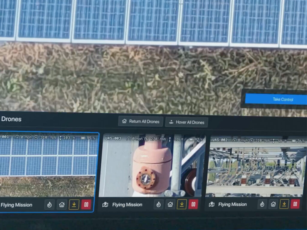
The integration of asset image analytics is revolutionizing vegetation management by equipping utilities with advanced tools for efficient monitoring and precise risk assessment. By combining technologies such as drones and satellite imagery with AI, utilities can analyze vegetation growth patterns on a large scale, reducing reliance on labor-intensive manual inspections.
Key technologies used in vegetation management
Drones and satellite imagery for monitoring large areas efficiently
Drones and satellites provide utilities with a high-resolution view of extensive service territories, offering a level of coverage and detail that traditional ground-based methods cannot match. These tools enable utilities to monitor vegetation growth near power lines with minimal disruption and without requiring field crews to access remote or hazardous areas.
Drones and satellites can capture asset images from multiple perspectives, including overhead and angled views, that are impossible to achieve from the ground. This capability allows utilities to detect issues such as vegetation encroachment, density, and proximity to infrastructure with unparalleled accuracy, enhancing the precision and effectiveness of vegetation management efforts.
AI algorithms to detect and classify vegetation species and growth patterns
Advanced AI models analyze imagery to classify vegetation types, assess proximity to critical infrastructure, and predict growth patterns. These insights allow utilities to focus on vegetation that poses the highest risks, ensuring efficient and effective management.

Use cases for asset image analytics in vegetation management
Identifying high-risk zones near power lines
By analyzing data from aerial imagery, utilities can pinpoint areas where vegetation encroachment poses the greatest risk of outages or fire hazards. This approach enables proactive intervention to reduce potential safety threats.
Automating compliance tracking for regulatory requirements
Asset image analytics simplifies the documentation of vegetation management activities, ensuring utilities meet clearance standards and regulatory expectations. This automation reduces manual efforts and improves the accuracy of compliance tracking.
Outcomes of leveraging asset image analytics
Faster, more accurate assessments compared to manual inspections
Traditional methods are often slow, subjective, and labor-intensive. Asset image analytics offers consistent and objective evaluations, accelerating the risk assessment process and enabling faster data-driven decision making.
Optimized resource allocation for trimming and clearing
With precise data on vegetation risks, utilities can prioritize high-risk zones and deploy resources efficiently. This reduces unnecessary trimming and ensures that critical areas receive immediate attention, thus saving time and lowering costs.
Implementing machine learning for risk assessment in vegetation management
Machine learning has emerged as a powerful tool for enhancing vegetation management, providing utilities with the ability to assess risks with precision and efficiency. By leveraging data from multiple sources and training sophisticated models, utilities can shift from generalized maintenance practices to targeted, proactive strategies that mitigate risks effectively.
How machine learning works in vegetation management
Gathering data from multiple sources
Machine learning relies on diverse datasets to generate actionable insights. Utilities can integrate data from drone footage, satellite imagery, weather conditions, historical incident reports, and vegetation species profiles to create a comprehensive picture of potential risks.
Training models to predict risk levels
Using this integrated data, machine learning models are trained to assess and predict risk levels for specific areas or even individual trees. These models factor in variables such as vegetation proximity to power lines, growth rates, species-specific ignition risks, and regional weather patterns.
Applications of machine learning in vegetation management
Prioritizing areas for maintenance based on risk scores
By assigning risk scores to specific zones, machine learning helps utilities identify the most critical areas that require immediate attention. This targeted approach ensures that resources are focused on mitigating the greatest risks, reducing the likelihood of outages and fire incidents.
Optimizing schedules for inspections and clearance operations
Machine learning enables utilities to move beyond static, schedule-based inspections. They can create dynamic schedules that prioritize high-risk areas and adjust in real time based on changing conditions, such as weather or seasonal vegetation growth.
Impact of machine learning on vegetation management
Data-driven decision-making
Machine learning equips utilities with precise, actionable insights, reducing the need for blanket maintenance and unnecessary expenditures. By focusing efforts on the highest-risk areas, utilities can significantly lower costs while improving the effectiveness of their vegetation management programs.
Enhanced risk mitigation
Predictive models enable utilities to anticipate potential issues before they arise, ensuring timely intervention and reducing the likelihood of incidents such as outages or wildfires.
Validating vegetation management plans for regulatory compliance
Wildfire mitigation plans (WMPs), currently mandated in states like California, are becoming a best practice adopted by more states to address growing wildfire risks. Compliance isn’t just about clearing vegetation—it’s about providing measurable, data-driven evidence that all activities effectively mitigate risks. Achieving this level of validation requires advanced strategies and tools to streamline documentation, ensure transparency, and align with regulatory expectations.
Compliance challenges in vegetation management
Meeting requirements of wildfire mitigation plans (WMPs)
WMPs demand utilities take proactive measures to reduce wildfire risks, including regular vegetation inspections and maintenance. Demonstrating that these activities are both consistent and effective can be a significant challenge, particularly for utilities managing extensive service territories.
Documenting and validating vegetation management efforts
Utilities are required to produce comprehensive reports to validate compliance with WMPs. This involves tracking all vegetation management activities, analyzing their outcomes, and ensuring high-risk zones are prioritized. Without robust systems and processes in place, these documentation efforts can be time intensive and prone to gaps.
Strategies for validating vegetation management plans
Using statistical methods to analyze historical vegetation data
Statistical analysis enables utilities to assess trends in vegetation growth and maintenance activities over time. By comparing historical and current data, utilities can validate the success of their strategies and demonstrate measurable improvements. In this case, applying statistical techniques allowed the utility to focus its efforts on areas where historical data highlighted recurring risks.
Leveraging machine learning models to demonstrate effectiveness
Machine learning models enhance validation efforts by predicting the outcomes of vegetation management activities. These models analyze data such as growth patterns, weather conditions, and species-specific risks to evaluate the effectiveness of trimming and clearing efforts.
Benefits of validating vegetation management plans
Improved transparency and accountability
Data-driven validation creates transparency by providing clear, verifiable insights into vegetation management efforts. Utilities can showcase the impact of their actions, build trust with stakeholders, and ensure accountability across all levels of their operations.
Stronger case for regulatory approval and funding
Validation strategies strengthen a utility’s case for regulatory approval and funding. By demonstrating the success of vegetation management plans, utilities can secure necessary resources while minimizing delays or penalties associated with non-compliance.
Integrating wildfire risk modeling into vegetation management
Wildfire risk modeling is a game-changing tool for utilities seeking to enhance their vegetation management strategies. By incorporating predictive insights into operations, utilities can better understand potential hazards, prioritize interventions, and reduce the likelihood of wildfire ignition. This approach aligns vegetation management efforts with broader risk-awareness frameworks, enabling providers to address threats proactively and systematically.
Understanding wildfire risk modeling
Wildfire risk modeling integrates with utility operations by embedding risk awareness into every step of vegetation management. This approach ensures that decisions are guided by data-driven insights, helping utilities anticipate and mitigate risks more effectively.
Risk modeling considers critical variables such as vegetation density, proximity to power lines, regional climate conditions, and historical fire patterns. By identifying areas with the highest risk, utilities can target their vegetation management efforts where they are needed most.
Operationalizing insights from wildfire risk modeling
With risk modeling insights, utilities can prioritize vegetation clearing and trimming in zones where wildfire risks are most acute. This ensures that resources are allocated efficiently, focusing on areas with the greatest potential to reduce ignition hazards.
Utilities can complement vegetation management with additional strategies such as grid hardening and real-time monitoring. For example, risk models may indicate where installing insulated power lines or deploying IoT sensors can further reduce fire risks.
Enhancing situational awareness through data integration
Data integration is revolutionizing vegetation management by providing utilities with a clearer, more comprehensive view of risks and system health. By consolidating diverse datasets into a single, unified platform, utilities can make faster, better-informed decisions to mitigate risks and maintain compliance.
Utilities generate vast amounts of data from multiple sources, including IoT sensors monitoring environmental conditions, weather forecasts, high-resolution satellite imagery, and field inspection reports. By integrating these data streams into a single dashboard, providers can view all relevant information in one place, eliminating silos and improving efficiency.
Advantages of data integration
Comprehensive visibility into vegetation health and risks
Integrated dashboards provide utilities with a holistic view of vegetation-related risks, enabling teams to track growth patterns, identify high-risk zones, and predict potential hazards with greater accuracy. This visibility allows for proactive vegetation management and more precise risk assessments.
Improved coordination across utility teams
Data integration fosters collaboration by ensuring all teams, from field crews to operations managers, work with the same up-to-date information. This alignment enhances communication, minimizes redundant efforts, and ensures that resources are deployed where they are needed most.
Tools for data integration
Predictive analytics platforms
Predictive analytics platforms process and analyze integrated datasets, providing utilities with actionable insights. These tools identify emerging risks, forecast vegetation growth, and recommend targeted interventions, empowering utilities to stay ahead of potential issues.
Centralized GIS systems for real-time decision-making
Geographic information systems (GIS) enable utilities to visualize integrated data on interactive maps, offering real-time insights into vegetation conditions and risks across service areas. These tools are particularly useful for planning maintenance schedules, tracking field activities, and responding quickly to new risks as they arise.
Shaping the future of vegetation management
The world of vegetation management is at a crossroads, where traditional methods are giving way to advanced, data-driven strategies. The stakes have never been higher—utilities face mounting challenges from climate change, regulatory scrutiny, and customer demands for uninterrupted service. Yet, within these challenges lies a powerful opportunity: the chance to redefine how providers manage risks, protect communities, and future-proof critical infrastructure.
Forward-thinking utilities are already investing in innovative technologies like AI, machine learning, and IoT to elevate their vegetation management programs. These innovations are more than just tools; they are enablers of transformation. By integrating predictive analytics, automating risk assessments, and embracing real-time data, utilities are meeting today’s demands while also laying the groundwork for a safer, more efficient future.
But technology alone isn’t enough. Collaboration will be the driving force behind the next era of vegetation management. Utilities must work closely with regulators, technology partners, and community stakeholders to create strategies that balance safety, efficiency, and sustainability. This collective approach ensures that solutions are scalable, equitable, and designed to withstand the evolving challenges of our time.
The future of vegetation management is about more than compliance or cost savings—it’s about creating resilient systems that can adapt to change, mitigate risks, and serve communities better. The question for utilities isn’t whether to evolve, but how quickly they can embrace the innovations shaping the industry’s path forward. The time to act is now.
References
Hauer, R. & Miller, R. (2021a). Utilities & Vegetation Management in North America: Results from a 2019 Utility Forestry Census of Tree Activities & Operations. Special Publication 21-1. College of Natural Resources. University of Wisconsin Stevens – Point. 69 pp. Utility Vegetation Management in North America – Results from a 2019 Utility Forestry Census of Tree Activities and Operations.pdf
Hauer, R. & Miller, R. (2021b, July 14). More than 20% of outages attributed to vegetation: UVM survey. T&D World. https://www.tdworld.com/vegetation-management/article/21169246/more-than-20-of-outages-attributed-to-vegetation-uvm-survey
Kennedy, C. (2015, August 26). Risk of very large fires could increase sixfold by mid-century in the US. National Oceanic and Atmospheric Administration (NOAA), Climate.gov. https://www.climate.gov/news-features/featured-images/risk-very-large-fires-could-increase-sixfold-mid-century-us
Smart Energy CC. (n.d.). New survey: Extreme weather and power outages. https://smartenergycc.org/new-survey-extreme-weather-and-power-outages/
About the Author
Adam Cornille is a hands-on executive with over 15 years of experience leading machine learning and data science initiatives. As the managing director of Logic20/20’s AI & Analytics practice, Adam specializes in applying innovative technologies to solve challenges in the utilities sector. Adam guides organizations in developing scalable, AI-powered solutions that enhance situational awareness, reduce operational risk, and increase regulatory compliance. His work spans vegetation management, wildfire prevention, and infrastructure resilience. Adam’s collaborative approach and practical application of advanced analytics enable utilities to modernize their operations while balancing safety, cost, and community trust.