A case study by Red Eléctrica de España, Elewit and Overstory.
Which tree, of the millions that are located near power lines, could be the one to grow into a powerline or fall and cause a power outage? That’s a question every electric utility around the world needs to think about. Overstory reduces that risk by using satellite data and machine learning to help its customers understand the position of trees, their height, their species and whether they’re healthy. With up-to-date insights at the tree level, Overstory helps utilities direct pruning efforts to areas most at risk, verifies pruning and helps utilities to spend O&M budgets most effectively.
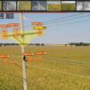
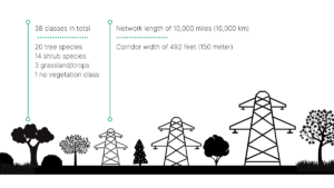
For Red Eléctrica de España (REE), identifying the vegetation species is key to managing risk and compliance. REE is responsible for 27,340 miles of transmission lines in Spain and is working with Overstory to classify 37 different species of vegetation along its lines. REE is a partly state-owned and public-limited Spanish corporation that operates the national electricity grid in Spain.
Identifying the tree species to understand risk
Like many utilities, REE wants to spend its vegetation management budget in the most efficient, targeted way possible. Knowing the tree and shrub species that grow near its lines is critical to understanding risks and prioritizing money and time spent around those risks.
In the past, it has been a real challenge to properly label or annotate all the species located near the right-of-way. Vegetation changes constantly, and mapping the tree species by hand meant having a snapshot for only a moment in time. Trees such as Pine and Eucalyptus grow quickly in Spain. Thus, there was a need to frequently monitor species in a more scalable, cost-effective and quality-controlled way. Technology from Overstory, which combines satellite images and machine learning, offered a perfect way to take on this challenge.
“The high costs of manual interpretation made the business case unbearable, until we discovered Overstory’s approach based on machine learning and satellite data.” -Iago Veiras Lens, Artificial Intelligence Partner at Elewit, Red Eléctrica Group

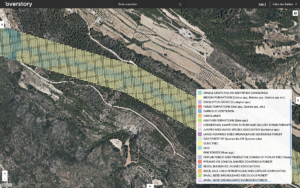
Tree species intelligence created by REE and Overstory
Optimizing budget via a risk-based pruning approach
REE is able to monitor 37 species across the 13 different climate zones of Spain. As a result of its collaboration with Overstory, REE now has a detailed and efficient-to-maintain vegetation map. The species identification, which is input to REE’s applications and algorithms, allows the company to manage the maintenance of the vegetation, optimize the budget by focusing pruning in the areas of greatest risk, and guarantee compliance with regulations.
“The vegetation management experts have validated the accuracy of the deliverables for all of mainland Spain and the Balearic Islands, and they’ve confirmed that the accuracy exceeded our expectations. The results from Overstory are currently implemented in the vegetation management cycle for 10,000 miles of powerline.” –Iago Veiras Lens, Artificial Intelligence Partner at Elewit, Red Eléctrica Group
Download the full case study here to learn more about:
- How Overstory and REE have combined satellite imagery and machine learning to identify vegetation species
- How the operational requirements were achieved and validated, including key variables such as accuracy, agility and affordability
- The business results of implementing the vegetation intelligence into REE operations
About Overstory
Vegetation is the single greatest contributor to wildfire and power outages on our electric grid. Through the application of AI and analytics to satellite imagery, Overstory helps utilities predict and prevent these problems. Overstory provides utilities with visibility, risk analysis, and optimization recommendations for vegetation management throughout their entire service territory.