For utilities that are just commencing their analytics journeys, LiDAR is the gateway drug to the world of data-driven, high-efficiency decision-making.
Light Detecting And Ranging (LiDAR) is a highly accurate method of digitizing three-dimensional (3D) objects. While many large utilities capture LiDAR on a frequent basis, some utilities still consider LiDAR too expensive, and believe the cost cannot be justified.
Well, I say that’s bollocks. For utilities that are just commencing their analytics journeys, LiDAR is the gateway drug to the world of data-driven, high-efficiency decision-making. Give me a few minutes to succinctly, conclusively demonstrate why no other data capture investment can pay so many dividends to so many diverse business units across a power company as LiDAR can.
Firstly, what is LiDAR?
A quick digression into some theory: LiDAR equipment works by firing a near-visible light beam at objects, then precisely counts the time before the beam reflects and returns to the source. By quickly firing many beams in many directions, LiDAR sensors can efficiently and precisely map gigantic areas in 3D, producing what is often called a “point cloud” (see below). LiDAR equipment can be hand-held, or mounted to cars or aircraft, depending on the capture requirements.
The point cloud dots are then “classified” into specific classes, enriching the raw points with information about what they represent – for instance “structure,” “conductor,” “vegetation,” “ground” and so on.
This classified point cloud forms the basis of all the analytics to follow.
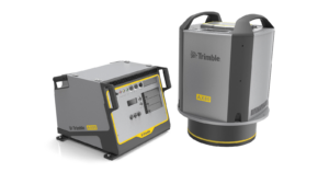
An example of aerial LiDAR capture equipment – The Trimble® AX60i
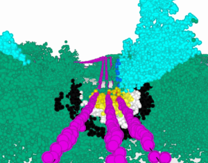
Point cloud classified as ground, vegetation, poles, cables, and buildings
Why LiDAR is so useful for utility analytics
Now, what can a utility do with its classified point cloud? Let’s first examine the two common and conventional applications of LiDAR scans, and then explore some of the more novel ways that LiDAR can support analytics across a utility’s many teams and departments.
1. Detecting vegetation encroachments
What it is: Apply clearance rules to the LiDAR scan, revealing with great accuracy all the vegetation encroachments across the network.
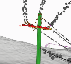
Point cloud with radial and fall-in encroachment zones visualized. Conductor points are purple, vegetation is green.
How it helps: management teams benefit the most from this application of LiDAR. Compared to traditional reactive or cyclic-based methods, LiDAR-based encroachment detection has immediate and clear advantages. Utilities eliminate the cost of scoping and inspecting lines before going to the site to trim. They can proactively address risk instead of waiting for something to happen. Furthermore, the cost of treatment often decreases due to the elimination of job volume uncertainty (trimming companies often charge higher prices due to the unknown size of the job). LiDAR scans reveal the precise quantity of foliage to be removed, allowing companies to estimate with greater accuracy.
2. Ground clearance violations
What it is: Apply clearance rules to the LiDAR scan, revealing every location in the network where the span is too close to the ground below it.
How it helps: Asset management teams can determine every incidence of clearance violation across the whole network. They can then work to mitigate those risks and enhance general network and public safety.
3. Understand more about the condition and health of every asset
What it is: With sufficient point cloud density, utilities can perceive and extract more granular asset health analytics. Pole lean, cross-arm cantering, and inter-conductor proximity can be extracted with even moderately dense LiDAR by using a software platform capable of detecting it.
How it helps: Asset Management and Network Risk teams can find and act upon asset risks that would otherwise be hard to detect. Cantered cross arms, leaning poles and close-to-touching conductors present risks that could cause network outages or significant physical risks.
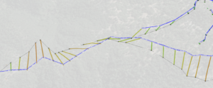
A cantered cross-arm extracted from LiDAR. Note that the pole and lines have been vectorized.
4. Extract precise asset locations, network-wide
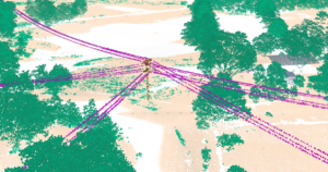
What it is: Use precise locations of assets in the LiDAR scan to correct other datasets the utility relies on, such as network GIS. Intelligent matching of LiDAR-extracted poles to GIS points can reveal “missing” and “found” assets – assets that exist in the GIS but not in reality, and vice versa.
How it helps: Maintenance and asset management teams cannot track, maintain or de-risk assets they can’t locate. If your utility doesn’t find significant discrepancies between what the GIS reports and what LiDAR reveals to exist, I’ll eat my hat.
It also is common for some poles to be hundreds of feet from their reported location, or simply not exist at all–making inspections, maintenance and general upkeep much more difficult, if not impossible.
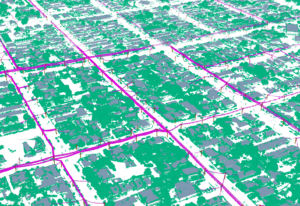
Asset location correction using LiDAR. LiDAR points in blue. GIS in black. Realignment vectors in color.
5. Better understanding of asset surroundings
What it is: Extract from LiDAR the traversability and slope characteristics of the ground below network assets.
How it helps: Understanding ground topology around network assets not only helps maintenance teams with site access, but also helps them make more informed decisions about prioritization and clearance. A slightly low line in a non-traversable location is much less of a danger than the same clearance violation above flat terrain.
6. A more intuitive visualization of your network
What is it: Host the LiDAR scan on a visualization platform to provide many teams with a model of the network, allowing them to search for assets, find feeders and inspect things in 3D during their normal course of work.
How it helps: A picture paints a thousand words. The LiDAR scan is effectively a 3D, high-detail “picture” of every asset in your network. Control room teams can use it to scope assets during incident response. Field operations teams can digitally inspect a pole before going to the site. Almost everybody, doing many different tasks, could benefit from orienting themselves with a highly accurate image of network model assets.
A large area of classified LiDAR
Final word
For utilities that are just commencing their journey to implementing more intelligent analytics, there are few investments more versatile or helpful than a LiDAR scan of the network. I have described just some of the many ways LiDAR can be used to improve network safety and economy. If the price of LiDAR seems prohibitive, consider the wide range of applications and foundational analytics use-cases it will enable. With the right tools to use it, LiDAR can recover its investment cost many times over.
Cody Yakimoff is product manager of the analytics solutions suite at Neara, a software company in North America and Australia that builds advanced, physics-based digital twins using LiDAR and other data sources.
Disclosure: Neither the author nor Neara are affiliated with LiDAR capture companies.